Tuesday, 18 April 2023

केमाक्ली आणि इजिप्त मध्ये येशू ख्रिस्त

मी ह्या आधीच्या लेखात म्हटलं होतं की टर्की आणि इजिप्त मध्ये प्रवास केल्यावर ख्रिश्चानिटीच्या तेथील प्राचीन पाऊलखुणांनी मला फार बुचकळ्यात टाकलं होतं. आज जरी तो संपूर्ण प्रदेश (इस्राएलचा अपवाद सोडून) इस्लामचा अनुयायी असला तरी ख्रिश्चानिटीच्या सुरुवातीच्या इतिहासातील अनेक महत्वाच्या घटना, युरोपमध्ये त्याचा सर्वदूर प्रसार होण्याआधी, ह्याचं भागात घडल्या. तो सर्वच इतिहास इथे सांगणं कठीण आहे. आज आपण त्यातील दोन महत्वाच्या पाऊलखुणा पाहू - एक टर्कीमधील आणि दुसरी इजिप्तमधील.

चौथ्या शतकाच्या सुरुवातीला रोमन सम्राट कॉन्स्टंटाईनच्या  फतव्यानुसार  ख्रिश्चन धर्माच्या अनुयायांचा छळ बंद होऊन ख्रिश्चानिटीच्या प्रसाराचा मार्ग रोमन साम्राज्यातील प्रदेशांत (इटली, टर्की, सीरिया, लेव्हन्ट इत्यादी) मोकळा झाला होता.

अर्थात तरीसुद्धा मूळ रोमन धर्माचे पाठीराखे आणि ह्या नवीन धर्माचे चाहते ह्यांच्यातील तेढ आणि प्रसंगी मारामाऱ्या, कापाकाप्या संपल्या असं नाही. ह्या सुरुवातीच्या काळात संख्याबळ पाठीशी नसल्या मुळे असेल कदाचित पण टर्कीच्या दऱ्याखोऱ्यात अनेक नव-ख्रिश्चन समुदायांनी अवघड जागी गुहा-गुफेत किंवा जमिनीखाली भुयारांचं जाळं खणून त्यांत आश्रय घेतला. त्यांचं एक उदाहरण (गोरेमीच्या गुहा) आपण ह्या आधीच्या लेखात पाहिलं.

केमाक्लीचं भूमिगत शहर हे (गोरेमीपेक्षाही थक्क करणारं) आणखी एक उदाहरण. केमाक्लीची स्थापना नक्की कधी झाली त्याबद्दल बरीच वेगवेगळी मतं आहेत. ख्रिस्त-पूर्व ७०० वर्षांपूर्वी फिरजियन टोळ्या ह्या जागी तुरळक गुफा खणून त्यांत राहत होत्या असा सर्वसामान्य समाज आहे. परंतु काही लोकांच्या मते त्याही आधी इ.स.पू. १२०० मधेच हिट्टाईट लोकांनी येथे जमिनीखाली आपली घरं खोदली  होती.  अर्थात एक गोष्ट नक्की - त्या तुरळक गुहांच्या समूहाचं एकसंध आणि कित्येक पातळ्यांवर जमिनीखाली खोल जाणारं “शहर” मात्र चौथ्या शतकांनंतर ख्रिश्चन धर्मियांनी बांधलं. 


आता पर्यंत पुरातत्वशास्त्रज्ञांनी केमाक्लीच्या भुयारांत ८ पातळ्या शोधून काढल्या आहेत, २०० फुटांपेक्षाही अधिक खोल जाणाऱ्या.

त्यापुढील एक हजार वर्षांपेक्षा अधिक काळ हे शहर सतत ३००० पेक्षा जास्त लोकांचं घर आणि आश्रयस्थान होतं - प्रथम मूळ रोमन धर्माच्या अनुयायांच्या छळापासून स्वतःला वाचविण्यासाठी, नंतर बिझन्टाईन काळात येथे होणाऱ्या अरब सैन्याच्या स्वाऱ्यांपासून आणि नंतर चौदाव्या शतकात आलेल्या तिमूरच्या मंगोल सैन्यापासून संरक्षण करण्यासाठी, तसंच जवळ-जवळ विसाव्या शतकापर्यंत येथे राज्य करत असलेल्या ऑटोमन सत्तेच्या छळापासून सुटका व्हावी म्हणून.


मात्र ह्या इतिहासापेक्षाही जास्त जाणून घेण्यासारखं आहे, केमाक्लीचं चकित करणारं स्थापत्य. एखाद्या गावात लागणाऱ्या सर्व सोई शेकडो फूट जमिनीखाली इथे होत्या - घरं, प्रार्थनास्थळं, सभामंडप, अगदी दारूचे गुत्ते सुद्धा. 


जमीखालील अंधारात त्याकाळात उजेडासाठी किंवा रोजच्या स्वयंपाकासाठी फक्त लाकूड, तेल किंवा तत्सम पदार्थ जाळणे हा एकाच मार्ग होता, त्यातून निर्माण होणाऱ्या धुरामुळे आतले लोक गुदमरून मेलेच असते. पण एव्हढ्या हजारो लोकांना श्वासोच्छवासासाठी लागणारी शुद्ध हवा पुरवणे आणि आतील दूषित हवेचा निचरा करणे ह्याची केमाक्लीमधील व्यवस्था थक्क करणारी आहे. हवा खेळती ठेवण्यासाठी अनेक जमिनी पर्यंत जाणारे उभे मार्ग ठिकठिकाणी खोदलेले आहेत आणि तेही अश्या चातुर्याने की वर अगदी शहराच्या डोक्यावर उभ्या असणाऱ्या माणसाला सुद्धा ते सहजी नजरेत येऊ नयेत. त्याशिवाय पाणीपुरवठा, शहरात साचणाऱ्या घाण/कचऱ्याची विल्हेवाट असे अनेक प्रश्न - जे जमिनीवरच्या शहरांत सुद्धा सोडवणे आव्हानात्मक असतं ते केमाक्लीमध्ये तर आणखीनच कठीण असणार. पण शहराच्या रचनाकारानी ह्या सर्वांची उत्तरं शोधली होती (त्याच्या खुणा आपल्याला दिसतात). पहा पहिले ४ फोटो (चर्च, दारू गाळण्याची फॅक्टरी, धान्याची कोठारं,  भुयारातील वाटा)  - पण नुसते फोटो बघून केमाक्लीची पूर्ण कल्पना येणं अशक्य आहे, प्रत्यक्ष त्या भुयारातील भूलभुलैयामधून वाट शोधत फिरल्याशिवाय. 


मात्र  इजिप्त मधला ख्रिश्चानिटीचा प्रवास टर्कीच्याही आधीच सुरु झाला होता असं दिसतं. ४२ सालीच संत मार्कने इजिप्तला येऊन प्रथम अलेक्झांड्रियामध्ये चर्च स्थापलं आणि धर्म प्रसाराला सुरुवात केली होती.

परंतु ४२ साल सुद्धा फार नंतरची गोष्ट झाली असं अनेक आख्यायिकांचं म्हणणं आहे. स्वतः मेरी, बाळ जीझसला घेऊन, त्यांच्या पाठलागावर असलेल्या रोमन सैनिकांची नजर चुकवत आश्रयाला इजिप्तला आली होती. नाईल नदीच्या काठाने उलटा सुलटा प्रवास (ह्या प्रवासाच्या कथित मार्गाचा नकाशा पहा पाचव्या फोटोत) करून शेवटी आजच्या कैरोमधील अबू सेगा चर्चच्या खालच्या गुहेत त्यांना आसरा मिळाला. आणि रोमन सैनिकांनी कंटाळून पाठलाग सोडून दिल्यावर ती दोघे परत जेरुसलेमला गेली, अश्या काहीश्या ह्या आख्यायिका आहेत. 


ज्या गुहेत ती दोघं राहिली त्याचा हा सहावा फोटो. हे जर खरं असेल, तर इजिप्त मधील ख्रिश्चानिटीचा इतिहास हा जवळ जवळ ख्रिस्त-जन्मापासूनच सुरु झाला असं म्हटलं पाहिजे.


हे अबू सेगा चर्च आणि “लटकतं” चर्च म्हणून प्रसिद्ध असलेलं पण “देवाची आई संत मेरीचं इजिप्तच्या बाबिलॉन मधील चर्च” अश्या लांबलचक नावाचं चर्च ईजिप्तमधील सर्वात प्राचीन ख्रिश्चन प्रार्थनास्थळं मानली जातात (संत मार्कने स्थापलेल्या पहिल्या शतकातील अलेक्झांड्रिया मधल्या चर्चची मूळ इमारत आज अस्तित्वात नाही). मुळातील बाबिलॉनचा किल्ला म्हणून प्रसिद्ध असलेल्या एका रोमन गढीच्या अवशेषांवर हे चर्च उभं केलेलं आहे. त्याला “लटकतं” म्हणण्याचं कारण म्हणजे चर्चचं मुख्य सभागृह त्या रोमन गढीतील जाण्या-येण्याच्या मुख्य मार्गावर अधांतरी बांधलेलं आहे.  ह्या “लटकत्या” चर्चची रचना फार पाहण्यासारखी आहे (पहा सातवा फोटो). एका बाजूने वेगवेगळ्या काळात बांधलेले बांधकामाचे थर, त्याच्या खोलातील पुरातन पाया पासून आजच्या चर्च (आठवा फोटो) पर्यंत स्पष्ट ओळखता येतात.

ही गढी नक्की कधी आणि कोणी बांधली ह्याबद्दल मात्र अनेक वाद आहेत. जेंव्हा रोमन सेनांनी इजिप्तच्या प्राचीन राजसत्तेचा पराभव करून आपलं राज्य स्थापन केलं तेंव्हा हा मूळ किल्ला बांधला असा एक समज आहे. तर दुसऱ्या कथेप्रमाणे फॅरो सेसोस्ट्रीस (किंवा सेनुस्रेत) ह्याने पुरातन बाबिलॉन बरोबरच्या लढायांत धरून आणलेले कैदी ठेवण्यासाठी ही गढी बांधली. पण तिसरी कथा अशी आहे की सत्य ह्याच्या बरोबर उलटं आहे. बाबिलॉनचा राजा नेब्यूकाडनझर ह्याने इजिप्तच्या सेनेचा पराभव करून पकडलेले कैदी ठेवण्यासाठी हा तुरुंग बांधला. जे काही असेल ते - पण अशा पुरातन प्रार्थनास्थळांच्या भोवती ख्रिश्चन धर्म प्राचीन इजिप्त मध्ये वृद्धिंगत  राहिला तो सातव्या शतकात खलिफा रशिदच्या सैन्याने इजिप्तमधील रोमन सत्तेचा पाडाव करेपर्यंत.


आजही ह्या मूळ ईजिप्शियन ख्रिश्चन (कॉप्टिक ख्रिश्चन) समाजाचे वंशज इजिप्तमध्ये पुष्कळ आहेत. खरं तर ख्रिश्चन धर्माच्या टर्की आणि इजिप्तमधील इतिहासाचा शोध घेण्याची कल्पना सुद्धा माझ्या डोक्यात आली ती ईजिप्तमधील कार्नाकचं देऊळ पाहून परत येताना आमच्या टॅक्सी चालकाबरोबर झालेल्या बोलण्या मधून. तो दिवस होता ख्रिसमसचा. टॅक्सीत बसल्याबरोबर चालक मागे वळून आम्हाला “Merry Christmas” म्हणाला. इजिप्तसारख्या मुस्लिम देशात ही नवलाईची गोष्ट होती म्हणून मी चौकशी केली तर तो निघाला  कॉप्टिक ख्रिश्चन - विस्मरणात गेलेल्या पिढयांपूर्वीपासून ख्रिश्चन असलेल्या कुटुंबातला. त्याने सांगितलेल्या दंतकथांतून माझं कुतूहल जागृत झालं आणि मग कैरो/अलेक्झांड्रियाला गेल्यावर वर वर्णन केलेल्या स्थळांना आम्ही भेट दिली!

Saturday, 15 April 2023

Neko Harbor

A bit of geography and historical context is in order, before I go on to describe the enchanting Neko Harbor - one of the most beautiful places I have ever visited.

Tourists like us are usually permitted to visit only the northernmost tip of the continent of Antarctica, called the Atlantic peninsula.

As is quite usual in this part of Antarctica, the Antarctic Peninsula is a politically disputed territory - claimed by Britain, Chile and Argentina. In what may be called one of the greatest land-grab operations run by the British, called Operation Tabarin during the second world war, they tried to annex most of the continent of Antarctica. Of course Both Chile and Argentina's claims on this land were based on their physical proximity - just about 1000 KM from Terra Del Fuego (which itself was a disputed land between Chile and Argentina until a treaty led to an amicable division between the two claimants).

Argentinians called the Antarctic Peninsula by the name Terra del San Martin (Land of Saint Martin) , the Chileans called it O'Higgin's land (Named after Bernardo O'Higgins - a revered leader who fought to liberate Chile from the Spanish) and the British called it Graham Land named after Sir James Graham who was the first Lord of Admiralty at the time a British survey expedition mapped this territory. To add to this confusion, there was a fourth claimant - the United States, who claimed it for themselves and called it Palmer Peninsula - named after a "famed" American Seal hunter called Nathaniel Palmer (why would someone want to immortalize a person who went around killing seals, is beyond me!)

But because of the Antarctic Treaty, none of these claims will be pursued by these nations and the land remains open to all for scientific research purposes. Moreover in 1964 a compromise was reached about the naming of this 1300 KM long strip of land as the "Antarctic Peninsula". It was further divided in three parts - The Trinity Peninsula (this the northern-most tip of Antarctica), Graham Land a bit to the south of Trinity Peninsula and further south, the Palmer Land (We never touched Palmer land).

This is the area which has "relatively" milder climate compared to all the rest of Antarctica (as high as 20 degrees Celsius BELOW zero without windchill on a good summer day!). Also the Antarctic Circumpolar Current provides a strong natural barrier, which results in the waters around the peninsula harboring a high percentage of diverse and endemic marine plants and animals. An estimated 75% of the krill population surrounding Antarctica resides in this area, supporting large breeding populations of penguins, seals, and whales. As a result most of the tourist activities (as well as maximum number of permanent research bases) are in this area.


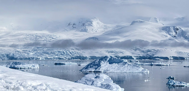
Neko Harbour is on the western edge of Graham Land facing the Gerlach Strait. Its arguably the most beautiful place on earth - at least among those which I have visited.


Neko harbor like many other locations on both sides of the Gerlach Strait, too was discovered and named by Adrien Gerlach during his 1897 expedition.

Some interesting trivia about his expedition. His was the first expedition team to spend a winter in Antarctica. The legend is that he deliberately drove his ship into a floating ice field to make sure it got stuck and his crew had no option but to spend the winter here! Also, two of the members of Gerlach's team would go on to be the first men on (a) South Pole (Roald Amundsen) and (b) the North Pole (Frederick Cook - However his claim was later rejected and the honor given to Robert Peary. Although the dispute was never conclusively settled).

Ironically, Gerlach named Neko Harbor after a Scottish whaling ship called Neko which used to operate in these waters and was responsible for slaughtering perhaps 1000s of whales in this area. Sealers, Whalers were the heroes in those times I guess - daredevils, going about on ramshackle ships into dangerous, unknows seas without a care or fear! Our sensibilities are quite different today and I guess we will call these guys villains and murderers! But they dared go where no man had gone before and that must be acknowledged, notwithstanding the carnage they wrought wherever they went.

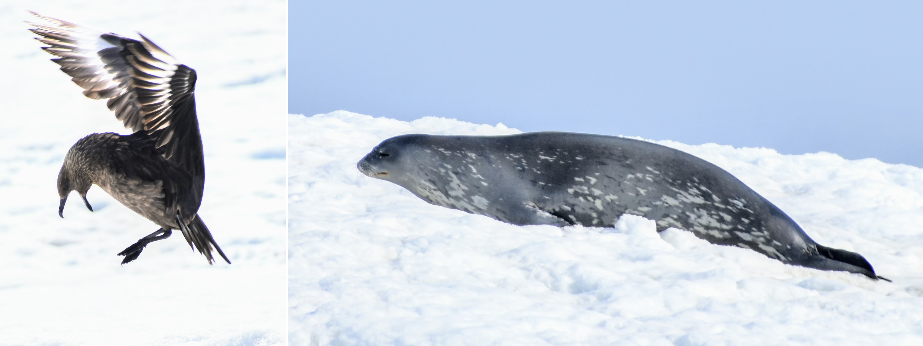
Neko harbor is home to a colony of Gentoo penguins and also Giant Southern Petrels as well as Skuas. Seals, especially Weddell seals too inhabit this area and are often found basking in the sun on the icy slopes of a hill that rises up from the harbor.

To use the word "spectacular" for the surroundings is a gross understatement. And as we climbed up the hill towards the Gentoo colony, more of it came into view including the edges of the Forbidden Plateau and it's other-worldly view, like the beauty of a snake - spellbinding and frightening at the same time.


The Forbidden Plateau - a section of Graham Land on the western edge where Neko harbor is - is  a very treacherous area which had for long defied many attempts by explorers to cross it on foot and survey it to create maps, hence the name. It's full of glaciers, deep crevasses and on its edge are steep icefalls (rapidly moving parts of an active glacier) called Blue Icefalls. 


During the summer, huge chunks of ice fall off the glacier in the waters of the harbor below - a process called calving. When you are at a distance - as we were up on the hill - this looks very interesting. Suddenly there is an avalanche and huge pieces of the glacier plunge into the sea below with a loud boom that reaches you seconds after you are done taking photos of the falling ice!


But as we were to discover shortly, up close those icefalls aren't as benign! Neko harbor is shaped liked a U with steeply rising hills on the arms of the U and there is a small area where there is a bit of a flat, pebbly beach when you can land. The beach is just about 6-8 feet wide and then the slope of the ice covered hill starts rising steeply.


To get to the Gentoo colony you have to cross the beach and climb up the hill. When we landed we were "warned" to not leave any gear on the beach (like life jackets etc) and not linger on the beach taking photos etc of the spectacular landscape or the penguins which were milling about there, but to immediately go up the hill and then do whatever we wanted.

We realized why that "warning" while we were returning. We had just boarded on our motor-boat (Zodiac) to go back to our ship and the last guy was getting in with one foot already inside. And suddenly the guy driving our Zodiac yelled, pulled the last guy in by his collar and set off at a reckless speed away from the beach.

I was sitting near the prow of the boat feeling very pleased with myself for having just got a lovely photo of one of these icefall across the bay from where our beach was.


As it happened, I had seen the beauty but not the sting of that icefall. This one was especially large and as it hit the water, it caused a huge wave - a small tsunami to spread. What was unbelievable was the speed with which the wave raced across the bay directly at us. It reached us just about a fraction of a second after the "boom" of the fall reached us! Now, when I look back, the wave was perhaps no more than 5-6 feet tall and the Zodiac simply floated up and down the other side and it felt no worse than being on a large roller coaster
but at that moment of panic, it looked gigantic, towering over us! After it had passed we turned back to the beach to see if anyone was stranded there. And the whole beach was flooded. Luckily none of our fellow travelers were on the beach when the tsunami hit it, otherwise they would surely have been washed away into the bay, as some of the lifejackets and haversacks were which few people had left behind on the beach when going up the hill, despite the warning!

Apparently, this is a frequent event at Neko harbor in summer, as the glacier calves. So my earlier analogy of it's beauty being like that of a snake was apt after all!


Friday, 14 April 2023

St. Peter's dopplegangers

During my recent trip to Antarctica Gulls and Petrels were around our boat quite frequently, lured by the krill, small fish etc getting pushed up closer to the surface by the churning of the waters by the boat's passage. 

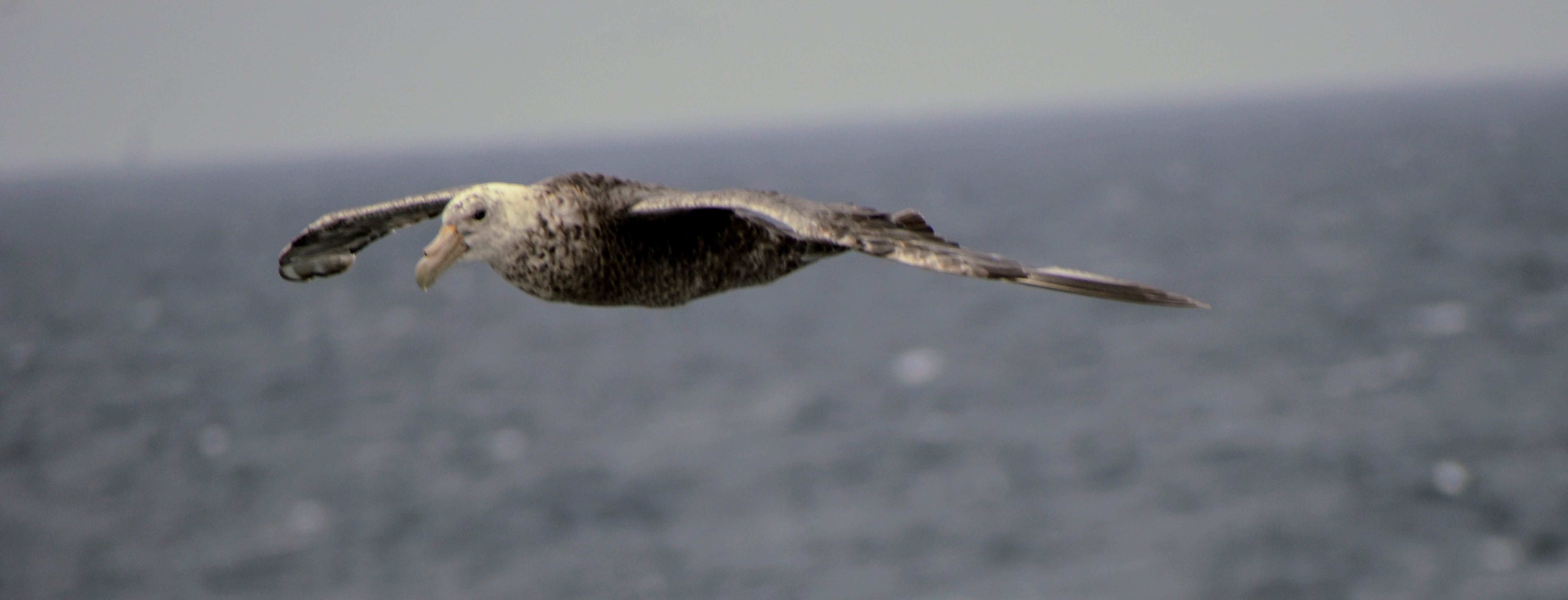
This was the first time that I saw Petrels - Storm Petrels, Cape Petrels and Southern Giant Petrels. 

But do you know why they are called Petrels??

William Dampier, an English explorer coined that word. Actually the original spelling was "Pitteral" - which changed over time to a simpler "Petrel". 

The Petrels spend most of their life on water - coming to land briefly only for breeding.  When the Petrel's take to the air while floating on the water - they appear to "Walk" on the surface of the water until they are fully air-borne. That walk reminded Dampier of St. Peter's walk on the surface of the Sea of Galilei, described in the Bible (in Matthew 14:29-31)! 

So he decided to call these new birds which were unknown to the Europeans "Like Peter" (Pitteral)! 

Here are some photos of one of the Petrels we saw - The Southern Giant Petrel.


The Southern Gian Petrels are big, adults have 7-8 feet of wingspan. 

BUT you should never think of keeping one as a pet!!! 

Because they brew a foul smelling liquid (that's why they are also called Stinkpot or Stinker) in their digestive system. They  spray this out of their mouth on their enemies/predators to scare them away. They also have a gland that separates salt from their blood. This excess salt  continuously oozes out of their nostril's giving them a permanent runny nose !!  

Anyway, here are the photos!


Friday, 7 April 2023

Port Lockroy

Port Lockroy in Antarctica is a place of historical importance that also happens be in a spectacular location, although the early part of that history is a story of blood and gore and a testimony to human cruelty.

Port Lockroy is the name of a bay (and also of the British base here) that forms a naturally sheltered harbor on the western shore of Wiencke island at the mouth of the Neumayer channel. The British base is located on an island called Gaudier island in this bay. See the map in the first photo.


Most of the Antarctic territory which our ship visited was explored and mapped mainly by two expeditions - 1. A Belgian expedition to Antarctica lead by Adrien Gerlache in 1897 and 2. A French expedition in 1904 by Jean-Baptiste Charcot. It was the Charcot expedition that gave the bay the name Port Lockroy - after a French politician who had funded the expedition. And it was the Gerlache expedition which came up with the other names - Wiencke after a member of the expedition who was washed overboard and drowned, Neumayer after a German explorer Georg von Neumayer.

The Neumayer channel itself is an interesting place - its a narrow passage between the Wiencke island and the much larger Anvers Island and connects the Gerlache strait and the open sea. Because of it's winding shape, icebergs often get caught in the channel and can't easily float out to the open sea.


Passing through the channel therefore provides out-of-this-world views of majestic mountains, ice-covered cliffs, steep glaciers, fantastically shaped icebergs (see the video and first couple of photos).


Anyway, coming back to Port Lockroy, before the British base was built, in the late 19th and early 20th century this was a bloody place. This had become one of the hubs of the whaling industry. The large Whaling "factory" ships used to dock here while the smaller, killer fleet went out to the seas to hunt and kill countless whales and bring the carcasses to the factory ships - where they were dismembered, the "valuable" parts like blubber, bones and meat separated and stored to be shipped back to Europe. There is no estimate of the scale of this massacre which continued for many decades until whaling was banned here and the whaling industry collapsed.

Then in 1944 in what might be called one of the biggest (and I might add, illegal) land grab operations, a British expedition code named Tabarin, came and staked ownership claims in the name of the king, on large tracts of land at many locations in Antarctica including Port Lockroy. Fortunately by the Antarctic treaty of 1959, territorial claims of ALL nations on any part of Antarctica have been held in abeyance - neither recognized nor rejected. Thus the land remains free for everyone - for scientific research, or just a visit like ours, or any other non-political, non-military, non-commercial activity.

Till 1962, Port Lockroy was a British station devoted mainly to weather research. Some of the earliest measurements of our ionosphere were made here, so also the first recording of a phenomenon called Auroral Chorus - electromagnetic waves generated by geomagnetic storms. After 1962 for nearly 3 decades it was abandoned. It was rebuilt as a historical monument and also as a tourist attraction in 1996. It now contains a museum of Antarctic explorations .

There is a post office here (The building to the right called Bransfield House) and also a gift shop. It is the Southern-most functioning post office! For a dollar you can post a letter to your home (which will most likely arrive months after you return home!)

We weren't allowed to land here though when our ship passed by. I am not sure why, perhaps it had not opened yet (its open only for a few months each summer) or perhaps our ship's permitted landing sites did not include Port Lockroy (All Antarctic tourist cruise ships are allotted specific routes and landing sites. They cannot go anywhere else). See the next few of photos showing the spectacular spot at which the station is located.


There is one curious object in one of the photos, if you notice - A three masted ship of a kind which may have sailed in the south seas during the 18th century! At first knowing that Port Lockroy is now a museum, I thought this may be the ship Discovery that brought Robert Scott and Ernest Shackleton to Antarctica on the first British expedition to that land. But later I found that Discovery is now a museum ship moored in Dundee in Scotland. So what could this be??

My best guess is that it is perhaps a Dutch ship called Barque Europa - The only sailing ship that is currently authorized to do Antarctic tours. At least the photos look quite similar!


But certainly that ancient look of that ship took me back for a moment to the Heroic Age of Antarctic Expeditions - that began with Andrien Gerlach (mentioned above) and ended with Shackleton's ill-fated 1922 expedition in which he himself died on South Georgia islands even before his ship had reached the Atlantic waters! It's hard to imagine now (especially after having actually seen the easiest-to-reach locations on a thoroughly modern ship), how, with the kind of equipment and technology they had, these people managed to explore one of the most difficult areas on earth and mostly managed to return alive!

Wednesday, 5 April 2023

Monument to Pioneers and Ancient Settlers

Quite close to the jetty where the cruise ships dock in Ushuaia, the southern-most city at the tip of South America (see the photo below of the port and city of Ushuaia) there is a very interesting structure called the Monument to Pioneers and Ancient Settlers (Monumento a los Pioneros y Antiguos Pobladores).

The design is truly beautiful - in the shape of a giant Albatross with its wings partly spread creating a semi-circular tranquil space within. The shape and its rendering manages to convey exactly what a pioneer or the first settler in an unknown country would be hoping to find - sanctuary, shelter and peace! See the two photos below.


It's when you get closer and see the decorations on the outer surface of the Albatross wings and in the inner space, that a tiny bit of dissonance starts building, especially if you are from a country that has experienced European colonial rule!

The decorations are meant to pictorially show the history of Terra Del Fuego - The Land of Fire as Magellan called it. There are pictures of Selknam (or Onawo) and their huts, of Yámana in their canoes (both indigenous residents of Terra del Fuego. It was the Yámana practice of lighting a community fire in all their settlements, every night that prompted Magellan to call this land, Terra del Fuego - the Land of Fire - when he saw a multitude of these fires lighting up the landscape as his ship navigated through what is today called the Magellan straits on his way to the Pacific ocean!
Then there are scenes of arrival of the Europeans in their schooners, pictures of the jail (which was what Ushuaia was originally - a town with the only purpose of incarcerating criminals in a jail), the train and the development of Ushuaia as a European colonial town!
When this monument was inaugurated in 2017, it was said that it represents the history which is "shared" by the original settlers and the immigrants who came here (That's why the name of the monument is "Pioneers and Ancient Settlers").
"Shared" ??
Of the "original" occupants of Terra del Fuego, the Selknam are an extinct tribe, they were systematically massacred by the gold diggers and farmers who came to Terra del Fuego and who usurped the habitats of the Selknam. The natives were plied with alcohol, deported, raped, and exterminated, with bounties paid to the most ruthless hunters. They were abducted and were exhibited in circuses in conditions of de facto slavery!
The Yámana (or Yahgan) too are now no more, after the last known full blooded Yámana and the last speaker of their original language died in 2022. But it was in the 19th century that the Yámana were largely decimated by the infectious diseases brought to Terra del Fuego by the Europeans against which the Yámana had no defenses. Those which survived the plagues, were thrown out of their lands by the European ranchers and settlers and hunted like animals just like they hunted other wild predators poaching their cattle and sheep. Only a handful survived because Anglican missionaries took some of them and resettled them on one of the islands of the Falkland group.
Such was the hubris of the European travelers who visited here that even a man like Charles Darwin describes them as and I quote "the miserable, degraded savages whom we first met here"
The monument is obviously silent on all this bloody and gory part of this "shared" history!
When you look at this beautiful monument once again - with this historical backdrop, you start wondering whether in fact this is a monument that celebrates the invaders, the colonizers, the robbers and thieves of the land that already had an owner, whether it is a monument that insults the original habitants by claiming that the lit fires in the their images on the walls of the monument, symbolize the union among natives and First Settlers.
On the rear side of the monument is a plaque paying ‘homage’ to the first 50 European settler families in the area, but none from the original inhabitants of this land are named. Perhaps because they are long dead and forgotten and when they were alive, they were not considered worthy of being included in the society!
There is a scathing critique of many of the monuments in South America called "Indigenous representation in public art" that calls out the colonial arrogance displayed in how the indigenous occupants of these parts are misrepresented in these monuments, that is worth reading. The link to that article is here -

https://michaelharrison.org.uk/2019/01/indigenous-representation-in-public-art-the-monuments-and-photographs/

Tuesday, 4 April 2023

The Mountain that Smokes

This is the spectacular journey from El Calafate to El Chalten in Argentine Patagonia - The pictures will speak for themselves ofcourse. The highlight of the trip was the amazing colors of the waters of two large lakes that the road skirts around, Lago Argentino, the largest lake in Argentina and Lago Viedma - sometimes sparkling blue, sometimes emerald green, and sometimes both hues at the same time.


The peak of Mt. Fitzroy (or Chalten) was shrouded in clouds when we reached the lovely little village of El Chalten but soon after the veil started lifting and we got at least brief glimpses of all those strangely shaped peaks in the Chalten range.

Most interesting (and something I didn't know) is one of the peaks is named after Saint-Exupery. The author of the endearing book Little Prince (if you haven't read it, you must, some day) this is the peak third on the left from the Fitzroy (Chalten) - the tallest peak in the range.

And just to make the day perfect came this soaring Andean Condor (forgive the quality of the photo - it was too far away to focus properly)


For a long time the native inhabitants of this area - Tehuelches - believed that this was a volcano, because the lofty peaks were always shrouded in plumes of white clouds. Their name for it El Chalten actually means Smoking Mountain. The European explorers who travelled through Patagonia were of course too arrogant to respect any local traditions, beliefs and cultures. So in a spree of renaming, All these peaks in the Chalten group were named after their friends, colleagues and bosses! 

In fact even the European explorers like Francisco Moreno who explored and mapped large parts of Patagonia thought this was a volcano. It was only in 1899 that a German naturalist Hauthal showed that the peak was solid granite and not a volcano at all. It was Moreno who renamed Chalten to Mount Fitzroy to honor Captain Fitzroy of the ship HMS Beagle who made two voyages to South America and beyond. Fitzroy was responsible for charting the Beagle channel (2nd of the three natural sea routes to go from Atlantic to Pacific. The 1st being Magellan Straits and the 3rd - Drake passage) and exploring large parts of what is today the Santacruz province of Argentina. On the second of these voyages he carried Charles Darwin on his ship. And you can read all about that in Darwin's book Voyage of the Beagle! So much for Fitzroy. 


But it is a spectacular sight, especially when the weather is kind and lifts the veils surrounding the peaks. The interesting thing about these peaks is ofcourse their shapes, almost like needles piercing the sky. As a result even though they are not very tall (Mt Fitzroy or Chalten - the tallest of them all is only a bit over 11000 ft), they have been very challenging to climbers. In fact Cerro Torre -little over 10000 ft only - in an adjacent group (not seen from where I took these photos attached below) has been called one of the most difficult peaks to conquer. The first recognized conquest happened as late as 1978 ( by which time most of Himalayan peaks, easily twice as tall as Torre, were sumitted multiple times). 


  विसरलेले समाज - २ : टुलोर   चिले देशातील अटाकामा असा प्रदेश आहे जिथे अनेक ठिकाणी गेल्या ५०० वर्षात पाऊसच पडलेला नाही. आणि जेथे पडतो तेथे...